Although we can’t predict the weather, by learning more about past weather we can make a more educated guess about the future. By understanding your garden’s microclimate, you’ll be able to choose plants that will thrive in your particular neck of the woods.
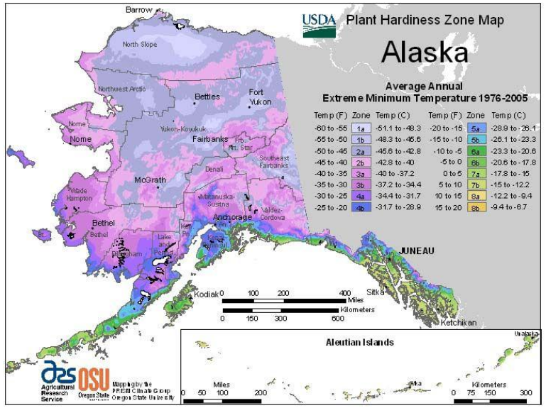
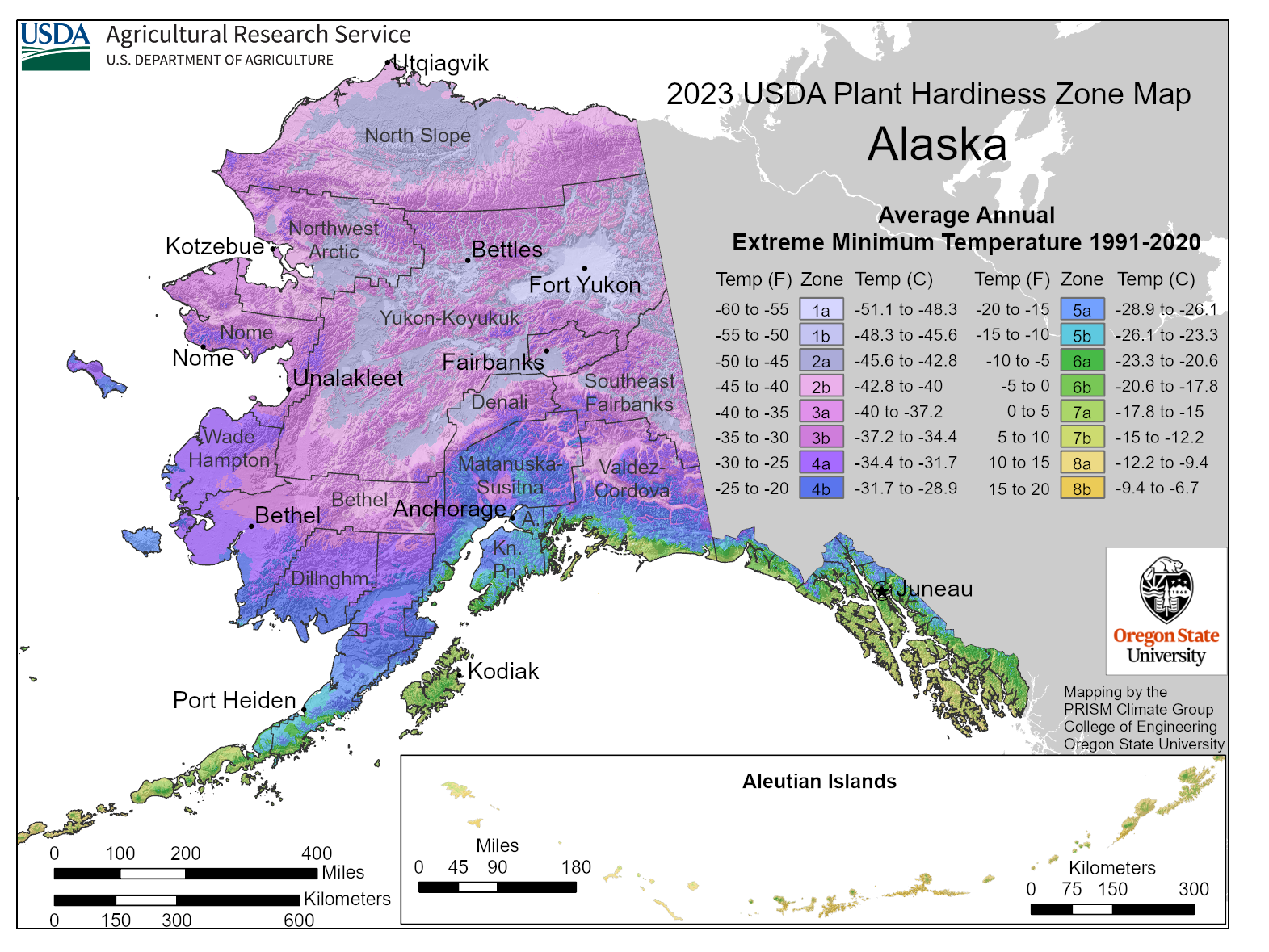
Many gardeners rely on the USDA Plant Hardiness Zone Map for a quick and dirty way to decide what to plant based on their “zone.” Zones are also a favorite qualifier of some nurseries and seed companies. Be aware that your zone is only based on the average annual extreme minimum temperature. The zones were just updated in 2023 and it’s interesting to compare the changes from the previous map.
I’m not going to tell you to set up a weather station in your back yard–although that would be the most accurate thing to do and there are some fairly inexpensive digital temperature monitors out there. I’m going to show you a couple of tools that will allow you to zoom in on the particular climactic conditions in your garden–all from the comfort of your armchair.
WunderMap is an easy to use tool to find highly localized weather information.
The NOAA tools are less straight forward and more complicated to use, but you can slice and dice the information however you would like. However, the most up to date information is not always available either. To use find NOAA weather information from the closest weather station to you, first go to NOAA Climate Data Online.
- Enter your community in the location box.
- In the “Select dataset” drop-down menu, select “Normals Annual/Seasonal.” Now you should be able to see on the map all of weather stations in and around Fairbanks. Find the station closest to your garden, then click on “Full details”. Note the elevation of the station. Is it very different from the elevation of your garden? Is there another nearby station with a more comparable elevation? Choose the station closest to you or with the most similar elevation. After you click on “Full details” you can either “View Data” or click “Add to Cart.”
- Checkout and enter your email address.
- Click, “Go back and complete another search” and follow the same procedures above, except this time, select, “Normals Monthly” from the drop-down menu.
- When the email says, “order complete” instead of “order submitted,” click “download” next to file.
I got excited about this web tool because there was a weather station very close to where I lived a few years ago. It showed that in the valley where I lived, there were three days in June and two days in July where the temperature dropped below 32 degrees. I compared that with a nearby, upland station and found that it did not drop below 32 degrees at all in June or July. That was a little depressing even though I already knew that I was in a cold zone, it was interesting to see the data.
The annual summaries are just a start and you may want to explore the NOAA tools further, keep your own records, or note the following characteristics of your garden:
- the first and last frosts of the season (and ugh mid-season frosts) which in turn determines the length of your growing season;
- the slope aspect of your garden or farm;
- hours of direct sun each day–not to be confused with the day length;
- day length;
- extreme weather or climate events.
You can also get a lot of this data with a very simple tool called the Alaska Garden Helper, but not in quite the same detail as the afore mentioned climate sites, especially in terms of better characterizing your micro-climate. It is particularly helpful in looking at how our climate has changed and predicting how it might change in the future. It also gives you a good estimate of what your growing season will look like in the future. For more information, check out:
- Alaska’s Changing Environment;
- Alaska Climate Research Monthly Climate Reports; and
- Alaska’s Climate Impact and Outlook Report.
Once you’ve determined the length of your usual growing season, plug-in your probable first frost-free day to Johnny’s Seed Starting Calculator to determine when to start what. Note that since this site is not specific to Alaska, it is not appropriate for some crops that do not grow here so you should also consult seed starting in Alaska. Your growing season is the number of days between the first and last frost. Use this number as a way to determine if a crop will mature (based on days to maturity), but be sure to factor in when you start the seeds indoors and whether or not you use season extension technologies.
This presentation explains in depth how Frost free Dates, Growing Degree Days and Hardiness Zones can be used in Alaska to inform decisions about growing crops in Alaska.
Although not exactly climate related, the USDA Web Soil Survey is another data tool that can be used to determine your soil types in many but not all areas of Alaska.
Weatherspark is a tool that can be used worldwide that also provides much of this information.
Previously published in the Fairbanks Daily Newsminer May 2, 2015. Updated April 2024.